Home Page
4 November 2005
DELAWARE ALLOTMENTS IN WYANDOTTE COUNTY
Allotment Listings and Maps

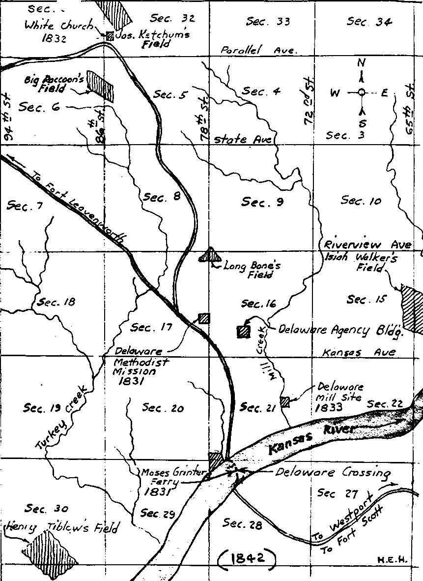
A Portion of the Delaware Reserve of the Area to the North of Moses Grinter's Ferry (Map by Harry Hanson)
This map is a portion of the Delaware Reserve showing roughly the area to the north of Moses Grinter's Ferry at the Delaware Crossing on the Kansas River in what is now Kansas City, Kansas. The area is in Range 24 East. The area covered by the map north of Parallel Avenue is in Township 10 South. The area south of Parallel Avenue is in Township 11 South. The map was drawn by Harry Hanson, one of the previous owners of the Grinter Place. This map, on page 16 of Faye Louis Smith Arellano's Delaware Trails: Some Tribal Records 1842-1907, was made by Harry Hanson, a former owner of the Grinter Place.
The Researchers for this project are Martin Weeks martinweeks@cox.net and Tom Swiftwater Hahn swiftwater@lenapedelawarehistory.net .
A Selection of Allotments of Delaware Lands in Kansas under the Treaty of May 1860 (As found in Faye Smith Arellano, Delaware Trails, pp. 26-64)
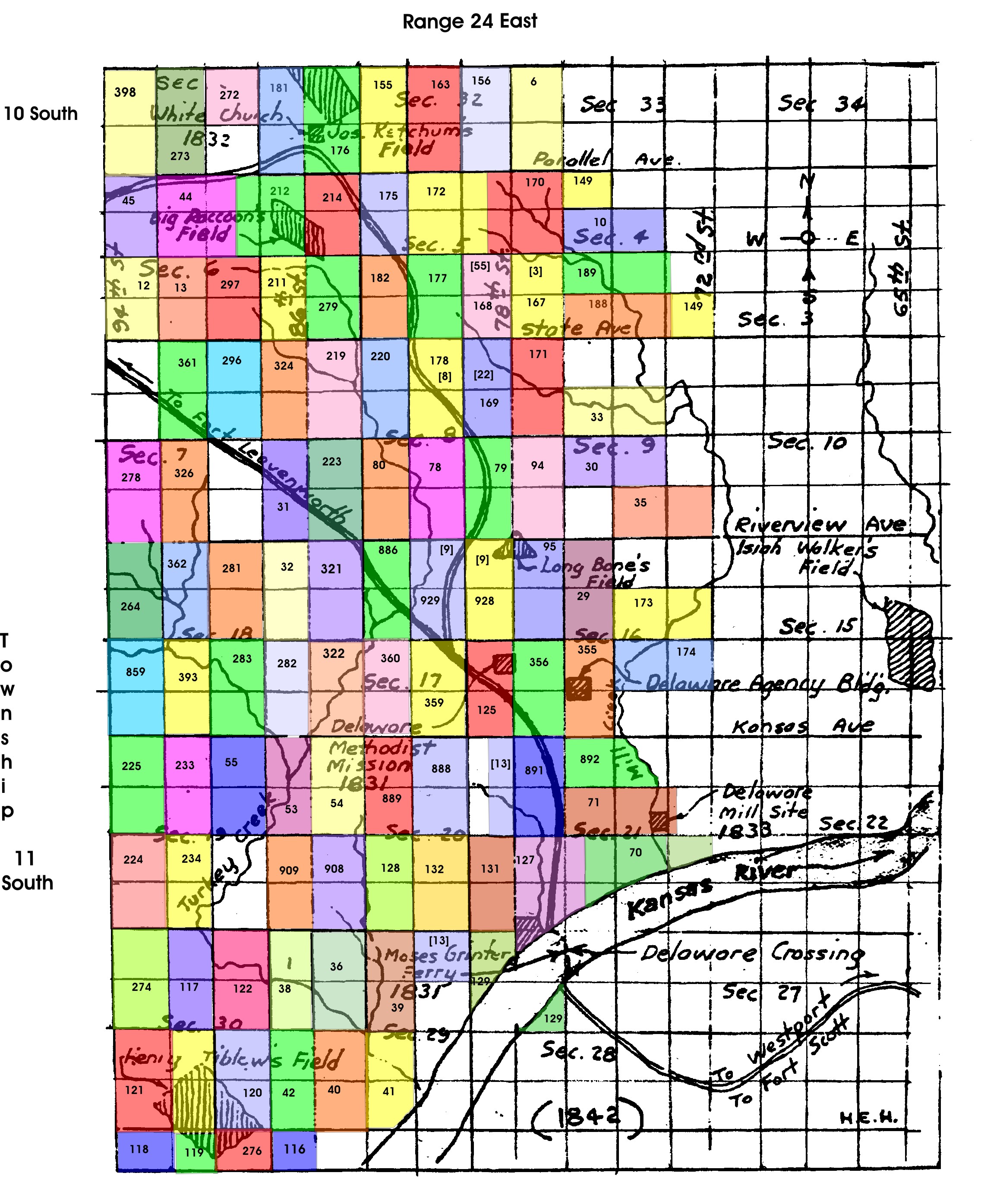
The allotments described herewith can be found on the map just below the listing.
The names we cite are from the 1862 Delaware Allotments, with some added 1866 allotments. We selected the names to match the area of the Hanson Map (above) that shows the area to the north of the Delaware Crossing on the Kansas River. That map is a good base for our purpose in that it includes section numbers, some road or street names, and certain Delaware features. The total number of allotments, included the 1866 additions, was 1182. The allotments that we show in the map comprise about ten percent of the total number of allotments. Each entry contains, in the order presented, the allotment number, the name of the person, the part of the pertinent section, the legal description of the allotment--including the section number, the township south, the range east--the age of the person, and the number of acres of each tract.
Sections consist of 640 acres of land. Thus, a half-section is 360 acres, a quarter section is 160 acres, and an eighth of a sections 80 acres, the intended acreage of each allotment. Most allotments are in one tract, but some are in two parts because of terrain features, the result being that the total allotment was about 80 acres. As an example of how this breaks down, take the first allotment below, which is No. 6, for Angeline Jonneycake. If one looks at the complete listing of allotments, it can be seen that Angeline's tract was not isolated from the remainder of the family's allotments, but those they were simply outside the scope of the map. This is not the case for most other allotments in the map area. In point of fact, the map entries tend to show the clustering of family allotments. The location of the allotments shows in general where the families had lived previously and shows that at least some choice was given. To continue, the next segment of Angeline Jonneycake's allotment is the legal description, which is W/2 SW/4 33-10-24. An expansion/explanation of that description is that her land was the west one-half of the southeast quarter of Section 33, Township 10, Range 24 East, the equivalent of 80 acres. Clear as mud, right? Actually, once you look up a couple of entries of the allotment map, the system should become clear to you. Angelina's age is 10 and the total acreage is 80 acres.
Number/Name/Age/Description of Allotment by Part of Section, Number of Section, Number of Township South, and Number of Range East, and Number of Acres. The age and number of acres has not yet been entered for every entry.
6. Angline Jonneycake, age 10, W/2 SW4, 33-10-24, 80 acres
10. Sally O. Smith, age 10, Lot 5 NE/4 4-11-24, 49.02 acres and SE/4 NW/4 , 4-11-24, 40 acres [total 89.2 acres]
12. R. Jordan Johnnecake, age 20, W/2 SW/4, 6-11-24, 80 acres
13. Rachel Johnnecake, age 16, E/2 SW/4, 6-11-24, 80 acres
29. Qua lup pa pa na qua, age 60, E/2 NW/4, 16-11-24, 80 acres
30. Mun da la qua Susan Beaver), age 7, NE/4 SW/4, 9-11-24, 40 acres and Lot 5 SE/4, 9-11-24, 48.8 acres [88.08 acres]
31. Oh how da pee ton (Mary Jane Beaver), age 3, E/2 SE/4, 7-11-24, 80 acres
32. Louisa Beaver, age 25, E/2 NE/4 18-11-24
33. Ne con se pa kee now [Virginia
Beaver], age 5 months, SE/4 NW/4 , 9-11-24 5 months and Lot 4 NE/4, 9-11-24,
48.42 acres [total 88.42 acres]
35. Nancy Wildcat Lot, age 16, Lot 6 SE/4 , 9-11-2,
47.70 acres and SE/4 SW/4, 9-11-24, 24.40 acres
[total 72.1 acres]
36. Rosanna Marshall Grinter, age 30, W/2 NW/4, 29-11-24, 80 acres
37. Juliet Grinter , age 11, E/2 NE/4, 36-11-23, 80 acres
38. Henrietta Grinter, age 10, E/2 NE/4, 30-11-24, 80 acres
39. Maria Jane Grinter, age 8, E/2 NW/4, 29-11-24, 80 acres
40. Sarah F. Grinter, age 4, W/2 SW/4 , 29-11-24 , 80 acres
41. Mary Belle Grinter, age 4, NE/4 SW/4, 29-11-24,
40 acres
and Lot 5 SW/4, 29-11-24, 38.20 acres
[total 78.2 acres]
42. James A. Grinter, age 1, E/2 SE/4, 30-11-24, 80 acres
43. Annie Marshall [dead] [daughter of John Marshall], age 8, Lots 5 & 6 SE/4, 36-11-23, 77.60 acres
44. Mary Gillis Rodgers, age 36, E/2 NW/4, 6-11-24, 54.32 acres and W/2 W/2 NE/4, 6-11-24, 27.31 acres [total 81.63 acres]
45. Sophronia Rodgers, age 10, W/2 NW/4, 6-11-24, 54.32 acres and E/2 E/2 NE/4, 26.78 acres [total 81.10 acres]
53 . John Delaware (gone south), age 38, E/2 NE/4 , 19-11-24, 80 acres
54. Jane Delaware [Wil la no oh qua?] (gone south), age 38, W/2 NW/4, 20-11-24, 80 acres
55. Me mun dat Delaware [Sar con oh kee now)], age 13, W/2 NE/4, 18-11-24, 80 acres
70. Betsy Marshall, age 65, Lot 6 SW/4, 21-11-24, 56.30 acres and Lot 5 SE/4, 21-11-24, 41.65 acres [total 97.95 acres]
71. Eliza Jane Fish, age 28, Lot 4 NE/4, 21-11-24,
49.30 acres and SE/4 NW/4, 21-11-24, 40 acres
[total 89.30
acres]
72. Sarah Ann Rankins, age 30, E/2 SW/4, 20-10-23, 80 acres
73. Alice Rankins, age 6, W/2 SW/4 , 20-10-23, 80 acres
78. Frances C. Grinter, age 22, W/2 SE/4, 8-11-24, 80 acres
79. Mary E. [L?], age 5, E/2 SE/4 , 8-11-24, 80 acres
80. John W. Grinter, age 1, E/2 SW/4, 8-11-24, 80 acres
94. Longbone, age 58, W/2 SW/4, 9-11-24, 80 acres
95. Mary Longbone, age 48, W/2 NW/4, 16-11-24, 80 acres
116. Henry Tiblow, age 40, Lots 2 & 3 NE/4. 31-11-24, 75.10 acres
117. Mary A. Tiblow, age 30, E/2 NW/4, 30-11-24, 80 acres
118. Virginia Tiblow, age 13, W/2 NW/4, 31-11-24,80 acres
119. Mary C. Tiblow, age 11, E/2 NW/4, 31-11-24, 80 acres
120. Richard W. C. Tiblow, age 6, W/2 SE/4, 30-11-24 , 80 acres
121. Nathan Tiblow (deceased), age 8 months, W/2 SW/4, 30-11-24, acres
122. Nancy Cook, age 50, W/2 NE/4, 30-11-24, 80 acres
125. Mary Jane [Grinter] Defries, age 19, E/2 SE/4, 17-11-24, 80 acres
127. Annie [Marshall] Grinter, age 40, Lots 7 & 8 SW/4, 21-11-24, 78.?? acres
128. William Henry [H.] Grinter, age 20, E/2 SW/4, 20-11-24, 80acres
129. Martha V. Grinter, age 5, Lots 2 & 3 NE/4, 29-11-24,
78.70 acres and Lot 4 NW/4, 28-11-24, 5 acres
[total 83.70
acres
131. Rosanna Marshal [Johnís daughter], age 10, E/2 SE/4 , 20-11-24, 80 acres
132. John Marshall [son of John], age 9, W/2 SE/4 , 20-11-24,80 acres
149. Elizabeth Ketchum, age 16, Lot 4 SE/4, 4-11-24, 49.02 acres and NE/4 NW/4 , 4-11-24, 40 acres [total 89.02 acres]
155. Lewis Ketchum, age 50, E/2 SW/4, 32-10-24, 80 acres
156. Elizabeth Z. Ketchum, age 28, E/2 SE/4, 32-10-24, 80 acres
163. Solomon Ketchum, age 2, W/2 SE/4, 32-10-24, 80 acres
167. Sarah E. Ketchum [Daughter of William Riley Ketchum), W/2 SW/4, 4-11-24, 80 acres
168. Nancy Ketchum, age 13, E/2 SE/4, 5-11-24 , 80 acres
169. Joel Ketchum, age 10, E/2 NE/4, 8-11-24, 80 acres
170. Caroline Ketchum, age 8, W/2 NW/4, 4-11-24,
52.81 acres and E/2 NE/4, 5-11-24, 27.25 acres
[total 80.06
acres]
171. Absolom Ketchum, age 6, W/2 NW/4, 9-11-24,80 acres
172. Henry Clay Ketchum, age 3, W/2 NE/4, 5-11-24, 54.50 acres and W/2 E/2 NE/4, 5-11-24, 27.25 acres [total 81.75 acres]
173. Melinda Wilcoxen, age 34, Lots 3 & 4 NE/4, 16-11-24 , 95.93 acres
174. Lucinda Wilcoxen, age 11, Lots 5 & 6 SE/4 , 16-11-24. 97.66 acres
175. James Ketchum [Reverend], age 44, E/2 NW/4, 5-11-24, 64.65 acres and Lots 7 & 8 NE?/4 , 18-10-24, 21.70 acres [total 76.35 acres]
176. Lo a tow oh qua [Mrs. James Ketchum], age 39, W/2 SW/4 32-10-24, 80 acres
177. Mary Ketchum, age 7, W/2 SE/4, 5-11-24, 80 acres
178. Hester Ketchum [after 1866, Nannie H. Grinter], age 13, W /2 NE/4, 8-11-24 , 80 acres
181. Amanda Ketchum, age 3, E/2 SE/4, 31-10-24, 80 acres
182. Charles Ketchum, age 17, E/2 SW/4, 5-11-24, 80 acres
188. George Ketchum, age 75, Lot 3 SE/4, 4-11-24,
49.02 acres and SE/4 SW/4, 4-11-24, 40 acres
[total 89.02
acres]
189. Mary Ketchum, age 48, Lot 3 NE/4, 9-11-24,
48.83 acres and NE/4 NW/4, 9-11-24, 40 acres
[total 88.93
acres]
211. Big Raccoon (dead), age 48, E/2 SE/4, 6-11-24, 80 acres
212. Sally Raccoon , age 40, E/2 NE/4, 6-11-24, 54.62 acres and E/2 W/2 NE/4, 6-11-24, 27.31 acres [total 81.93 acres]
214. Ah qual pe now, age 21, W/2 NW/4,
5-11-24, 54.65 acres and W/2 E/2 NE/4, 1-11-23, 26.78
acres
[total 81.43 acres
219. Twe sho quo he [Que she qua he], age 45, W/2 NW/4, 8-11-24, 80 acres
220. Martha Jacobs, age 6, E/2 NW/4, 8-11-24, 80 acres
223. Jim Brown, age 27, W/2 SW/4, 8-11-24, 80 acres
224. A ha le ma le mon, age 28, W/2 SW/4, 19-11-24 , 80 acres
225. To ha le no oh qua, age 10, W/2 NW/4, 19-11-24, 80 acres
233. Ah ha la nah que now, age 28, E/2 NW/4, 19-11-24 , 80 acres
234. Ne la ta que now, age 35, E/2 SW/4, 19-11-24 , 80 acres
264. John Washington, age 7, W/2 NW/4, 18-11-24 ,80 acres
272. John George, age 1 month, SW/4 NE/4, 31-10-24,
40 acres and NW/4 SE/4 , 31-10-24, 40 acres
[total 80 acres]
273. Wa le car pi [Gustavus Davis], age 23, E/2 SW/4, 31-10-24, 80 acres
274. Mary Ann Fish, age 35, W/2 NW/4, 30-11-24 , 80 acres
276. Francis Tiblow, age 8, W/2 NE/4 , 31-11-24, 80 acres
278. Ke wee she, W/2 SW/4, 7-11-24, 80 acres
279. Abram Haff, age 30, W/2 SW/4, 5-11-24 , 80 acres
280. Tuc kee lun go nar qua, age 28, W/2 SE/4, 7-11-24 , 80 acres
281. Man ka no wha, age 6, W/2 NE/4, 18-11-24, 80 acres
282. Es pe lun go no wha, age 4, E/2 SE/4, 18-11-24, 80 acres
283. Kuch que cum un, age 2, W/2 SE/4, 18-11-24, 80 acres, 80 acres
296. Wa lun da koh oh qua, age 54, W/2 NE/4, 7-11-24 , 80 acres
297. Po me now. age 60, W/2 SE/4, 6-11-24,80 acres
321. Doctor Block, age 39, W/2 NW/4, 17-11-24 , 80 acres
322. Eliza Block, age 32, W/2 SW/4, 17-11-24, 80 acres
324. Leonard Snake, age 64, E/2 NE/4, 7-11-24, 80 acres
326. Sampson Snake, age 10, E/2 SW/4 , 7-11-24, 80 acres
333. William Marshall, age 10, E/2 NW/4, 19-10-24, 80 acres
344. Polly Marshall , age 3, W/2 NE/4, 19-10-24 , 90 acres
355. Par tet Longbone, age 17, E/2 SW/4, 16-11-24, 80 acres
356. Ar sar kee par ke no, age 19, W/2 SW/4, 16-11-24 , 80 acres
359. Quaf ti lease Longbone [Nancy Fish), age 32 [dead], W/2 SE/4, 17-11-24, 80 acres
360. Pa mo hah Longbone, age 4, E/2 SW/4, 17-11-24 , 80 acres
361 Qua ta che hease, age 48, E/2 NW/4 , 7-11-24 , 80 acres
362. Robert Washington, E/2 NW/4 18-11-24, 80 acres
393. Puate pa coo wha, age 30 E/2 SW/4, 18-11-24, 80 acres
398. Oh well lun noox qua, age 80, W/2 SW/4, 31-10-24, 80 acres
859. Ton qua chuch, age 26, age 26, W/2 SW/4, 18-11-24
886. Jenny Armstrong, E/2 NW/4, 17-11-24, 80 acres
887. John Shawnee, [41-46 apparently Shawnee?] E/2 (half off) NE/, 20-11-24, 80 acres
888. Betsy Shawnee, W/2 NE/4, 20-11-24, 80 acres
889. Susan Shawnee, E/2 NW/4 , 20-11-24, 80 acres
890. John White, E/2 NW/4, 30-11-24, 80 acres
891. Big Shawnee, W/2 ,NW/4 , 21-11-24, 80 acres
892. Jane Shawnee, NE/4 NW/4, 21-11-24, 40 acres and Lot 3 NE/4, 21-11-24, 49 acres [total 89 acres]
908. Martha Edgar , age 32, W/2 SW/4 , 20-11-24, 80 acres
909. Eliza Edgar, age 12, E/ 2 SE/4 , 19-11-24, 80 acres
928. Lucinda Marshall, age 35, E/2 NE/4 , 17-11-24, 80 acres
929. Rebecca Lucas, age 60, W/2 NE/4, 17-11-24 , 80 acres
942. Francis H. Grinter, Lot 2 SW/4, 30-10-23, 7.27 acres
1866 Additions Ė Shown in Brackets on Map
3. Anna E. Defries [1866], W/2 SW/4, 4-11-24,
8. Nannie H. Grinter [1866], W/2 NE/4, 8-11-24 [previously owned by Hester Ketchum, daughter of James Ketchum]
9. Edward Grinter [1866], N/2 W/2 NE/4, 17-11-24 and N/2 E/2 NE/4, 17-11-24
13. Cunningham Grinter [1866], NW/4 NE/4, 29-11-24 and E/2 E/2 NE/4 , 20-11-24
22. Flora Grinter [1866], E/2 NE/4, 8-11-24
55. Emmet Wilcoxen [1866], E/2 SE/4, 5-11-24

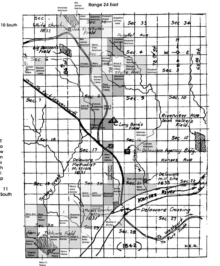
Allotments Plotted on the Hanson Map of a Portion of Wyandotte County
An offset between the section for Townships 10 and 11 South for the cross-index map does not appear in the Hanson map. The only area affected is the allotments in Township 10 South which may not be exactly as depicted in the map above. However, the Hanson map may be correct as the county was re-surveyed at some later point in time. Most likely, however, Mr.. Hanson drew a very good map but forgot to show the offset because it was mostly irrelevant to what he was trying to show. One item of interest in Township 10 South is White Church. (The map was prepared by Martin Weeks.)

A Portion of the Delaware Reserve of Area to the North of Moses Grinter's Ferry Showing Some of the 1862 Delaware Allotments by the name of the recipient. See the caption in the previous map regarding the possible incorrect location of allotments in Township 10 South. (Martin Weeks prepared this map using the Hanson map as a base.)

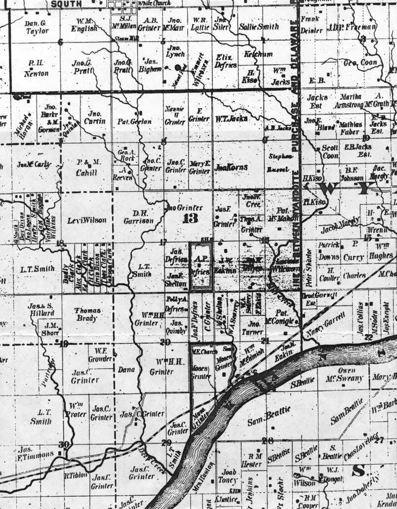
Map of Wyandotte County, Kansas. Wyandotte, Kansas 1870
Of particular interest is a comparison of this map with the one showing the 1862 allotments and 1866 additions after the mainstream of the Delaware went to Indian Territory (Oklahoma) and adjustments of land were made.Times New Roman 12 point. Copy 11 December 2004 from program. TH